Vacanze al Lago di Molveno, Dolomiti di Brenta
![]()
![]()
![]()
![]()
![]()
![]()
![]()
![]()
![]()
![]()
![]()
![]()
![]()
![]()

|
Dolomiti di Brenta, Rifugio alla Tosa, Tommaso Pedrotti The Pedrotti Refuge stands on a rocky crag just a few metres
from the Bocca di Brenta pass. It is an excellent starting point for all
climbs towards the central peaks in the group. All walks in the Brenta
Dolomites from south-east to north-west pass through this point. |
|
GENERAL INFORMATION |
|
| Altitude | m.2491 |
| Location | Sella del Rifugio |
| number of beds | 120 |
| telefono , fax | 0461948115, fax 0461587003 |
| website - e-mail | |
| opening period indicative | 20 june - 20 september |
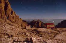
The Tommaso Pedrotti Refuge at dusk: in the background the
Pizzo Gallino peak
|
Access routes: from Molveno along Val delle Seghe , path 319 |
||||
| difference in height: m. 1627 | maximum height : m.2491, Rifugio Pedrotti | |||
| Description. classic access route to the refuge which climbs up from the Seghe Valley and the Massodi Valley via the Croz Altissimo (avoidable if you follow path 319) and Selvata refuges. | ||||
|
area |
height | time between areas | time from start | notes, route variations |
| Molveno,via Dolomiti | 880 | - | - |  Cartina su gentile concessione Editrice La Giralpina |
| Baita Ciclamino, bivio Sent.Donini | 926 | 10 | 0,10 | |
| Busa del Formai, fork 319-322 | 1300* | 50 | 1,00 | following path 319 you come directly to the Selvata Refuge |
| Rifugio Croz Altissimo, fork 322,340 | 1430 | 30 | 1,30 | path 340 to Pradel, 322 to the Perse Valley and the Clamer Pass |
| Rifugio Selvata, fork 332 | 1630 | 40 | 2,10 | to the Malga Andalo Refuge |
| Rifugio Pedrotti | 2491 | 140 | 4,30 | - |
|
Access routes:from Altopiano di Pradel along path 340. |
||||
| difference in height: m. 1170 | maximum height : m.2491, Rifugio Pedrotti | |||
| Description
: from the top station of the Molveno-Pradel cable car, take
itinerary 340, by far the most popular access route to the Brenta
refuges from the southern side. |
||||
|
area |
height | time between areas | time from start | notes, route variations |
| Altopiano di Pradel | 1320 | 0 | 0 | Cartina su gentile concessione Editrice La Giralpina |
| seghe del Marillon, fork Montanara | 1330* | 0,25 | 0,25 | |
| Rifugio Croz Altissimo, fork 322 | 1430 | 0,35 | 1,00 | |
| Rifugio Selvata | 1630 | 0,40 | 1,40 | |
| Rifugio Pedrotti | 2491 | 2,20 | 4,00 | |
 |
 |
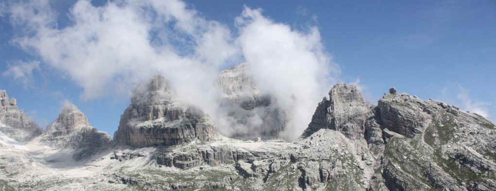
| Rifugio Pedrotti da ovest | Rifugio Pedrotti, Croz del Rifugio e Monte Daino |
|
Access route: from Molveno along the la Ceda Valley, path.326 |
||||
| difference in height: m. 1627 | maximum height : m.2491, Rifugio Pedrotti | |||
| Description : much less commonly used itinerary than the previous one, in unspoilt scenery and without refuges along the way. | ||||
|
area |
height | time between areas | time from start | notes, route variations |
| Molveno -Camping Strada Ponte Romano | 835 | - | - | Cartina su gentile concessione Editrice La Giralpina |
| fork 332- 326 | 925 | - | - | |
| La Vela , fork forrestry road for, s.326 | 1174 | - | - | the forestry road comes out near the Malga Andalo Refuge |
| rovine di Malga Ceda Alta | 1888 | - | - | possible detour along the San Lorenzo Valley to the Rossati Pass and the Doré Valley (Alpenrose Refuge) |
| fork 320-326 | 2414 | - | - | detour to the Forcolotta di Noghera pass and the Agostini Refuge |
| Rifugio Pedrotti | 2491 | - | 5 hours | - |
The Pedrotti seen from the Palmieri path
|
Access routes: from Molveno along Malga Andalo and Rifugio Selvata, on path . 332 and 319 |
||||
| difference in height: m. 1656 | maximum height : m.2491, Rifugio Pedrotti | |||
| Description : An alternative itinerary to the Seghe Valley route in the first stretch and includes a short part with fixed rope supports between the Malga Andalo and Selvata refuges. | ||||
|
area |
height | time between areas | time from start | notes, route variations |
| Molveno -Camping Strada Ponte Romano | 835 | 0 | 0 | Cartina su gentile concessione Editrice La Giralpina |
| fork 332- 326 | 925 | 0,15 | 0,15 | |
| Malga Andalo | 1357 | 1,15 | 1,30 | |
| Rifugio Selvata, fork 319,340 | 1630 | 1,15 | 2,45 | carry on along path 319 to the west |
| fork 319-303 | 2420 | 2,00 | 4,45 | detour along the Sentiero Orsi path |
| Rifugio Pedrotti | 2491 | 0,20 | 5,05 | - |
|
Access routes: from San Lorenzo, Rifugio Alpenrose, along Larì Prada Val Dorè and i Rossati. |
|
| difference in height: m. 1750 circa | maximum height : m.2491, Rifugio Pedrotti |
| Description: unusual, long and tiring route, only recommended for those hikers interested in the less popular routes. | |
| Start point | height | time from start | notes, route variations |
| Rifugio Alpenrose | 1074 | 0 | 
|
| fork 345-345b | 1541 | 1,20 | Going westwards path 345b joins path 351 and from here: a) northwards (i.e. turn right) to the Malga Ben and Al Cacciatore Refuge, b) to the south-west to the former Malga Dorsino and then along path 349b to the Mase Alte e Basse peaks until you come to the Ambiez Valley road |
| Passo dei Rossati | 2358 | 3,40 | - |
| Spigolo est Dalum | 1980* | 4,40 | Cutting east across the Ceda Valley you come to path 326 and going downhill you get to Molveno or to the Malga Andalo Refuge by turning left a short distance above the ruins of the Malga Ceda Bassa |
| Forcolotta di Noghera,fork 320 (destra) | 2423 | 6,10 | Turn west and it takes about 20 minutes to get to the Agostini Refuge |
| fork 320-326 (sinistra) | 2414 | 6,30 | A second way of heading for Molveno without passing the Pedrotti Refuge |
| Rifugio Pedrotti | 2491 | 7,50 | - |
 |
 |
| Rifugio Pedrotti, Croz del Rifugio e Monte Daino | Campanil Basso Brenta Alta e sulla sin. Rifugio Pedrotti |
|
Access routes: from S.Antonio di Mavignola alont the Brenta Valley, on path 323 and 318. |
||||
| difference in height: m. 1380 | maximum height : m.2552, Bocca di Brenta | |||
| Description:
one
of the access routes to the Brentei Refuge and, carrying on along the
Brenta Valley, to the Pedrotti Refuge. |
||||
|
area |
height | time between areas | time from start | notes, route variations |
| Parcheggio Val Brenta | 1172 | 0 | 0 |  Cartina su gentile concessione Editrice La Giralpina |
| ex malga Brenta Alta | 1687 | 2,00 | 2,00 | |
| fork 323-391 | 1704 | 1,00 | 3,00 | |
| Rifugio Brentei | 2175 | 0,30 | 3,30 | |
| Bocca di Brenta, fork 305 | 2552 | 1,00 | 4,30 | |
| Rifugio Pedrotti | 2491 | 0,10 | 4,40 | |
|
Access routes: Madonna di Campiglio along Vallesinella and Brenta Valley |
||||
| difference in height: m. 1380 | maximum height : m.2552, Bocca di Brenta | |||
| Description:
the most
popular access route to the Brentei Refuge |
||||
|
area |
height | time between areas | time from start | notes, route variations |
| Rifugio Vallesinella | 1513 | 0 | 0 | |
| Rifugio Casinei, sent 318 | 1825 | 1,00 | 1,00 | at
the Casinei Refuge take path 318. |
| Valle del Fridolin, fork | 2048 | 0,40 | 1,40 | - |
| Rifugio ai Brentei | 2182 | 1,00 | 2,40 | - |
| Bocca di Brenta, fork 305 | 2552 | 1,00 | 3,40 | - |
| Rifugio Pedrotti | 2491 | 0,10 | 3,50 | - |
Visualizza Parco Adamello Brenta, Settore Brenta in una mappa