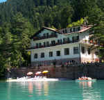
Vacanze al Lago di Molveno, Dolomiti di Brenta
![]()
![]()
![]()
![]()
![]()
![]()
![]()
![]()
![]()
![]()
![]()
![]()
![]()
![]()

|
Crossing the Brenta Dolomites, Trentino: from Molveno to Seo- Stenico As
far as the Agostini Refuge (overnight stay advisable either here or at the Al
Cacciatore Refuge) the itinerary is described in point 6 above (climb up from
the Ceda Valley) or in point 5, with the precaution of following the quieter
Palmieri path (no. 320) which links the Pedrotti Refuge to the Agostini Refuge
in less than 3 hours. |
| number of days required | 2 days |
| suggestions for overnight stays | Rifugio Agostini or Rifugio al Cacciatore San Lorenzo |
| starting point: | Molveno -Camping |
| finishing point: | Seo – Frazione di Stenico (valli Giudicarie) |
| maximum height: | mt 2415 – Forcolotta di Noghera |
| difference in height | about 1600 m. |
| time required | 14 - 15 hours |
| main peaks crossed | Val di Ceda, Val d’ Ambiez, Alpe Prato, Mughere, Prà del Vescovo, Busa di Senaso, Marugeni, Selletta Colmalta, Lago e Malga d’Asbelz, Selletta di Monte Piz, ex Malga Valandro, i Salti , Val d’Angol. |
| refuges etc. along the way | Rifugio Agostini, Rifugio al Cacciatore S. Lorenzo |
| path numbers | 332, 326, 320, 325, 348 |
| Bus Connections | Collegamenti autobus Trentino |
| level of difficulty | difficult and tiring |
| recommended period | june - october |
|
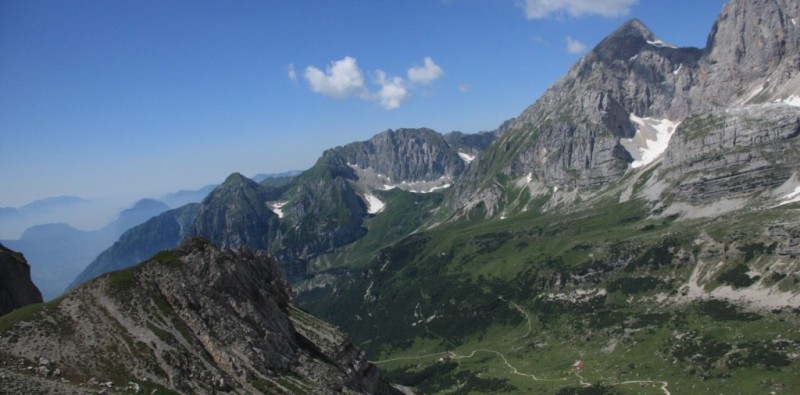
Forcolotta di Noghera and Cima Ghez |
Malga Asbelz |


 Cartina da Molveno a San Lorenzo su gentile concessione Editrice la Giralpina |
 Cartina Seo Val d'Angol su gentile concessione Editrice la Giralpina |
Table of times between points and heights:
| area | path nr. | height | time between areas | time from start | notes,
route variations
|
| Molveno -Camping Strada Ponte Romano | 332 | 835 | 0 | 0 | SEE MAP |
| fork 332- 326 | 326 | 925 | 0,10 | 0,10 | - |
| La Vela, fork strada for, s.326 | 326 | 1174 | 0,25 | 0,35 | The
forestry road goes near the Malga Ceda di Vailla |
| rovine di Malga Ceda Bassa | 326 | 1440 | 1,10 | 1,45 |  Rovine di Malga Ceda Bassa |
rovine di Malga Ceda Alta |
326 | 1888 | 1,20 | 3,05 | Possible detour along the San Lorenzo Valley to the Rossati Pass and the Doré Valley (Alpenrose Refuge). |
| Cresta est di Cima Ceda, fork 320 | 320 | 2414 | 1,40 | 4,45 | turn left |
| Forcolotta di Noghera, fork 345 | 320 | 2423 | 0,15 | 5,00 | - |
| Rifugio Agostini | 358 | 2410 | 1,00 | 6,00 | overnight |
| Busa dei Malgani, fork 351 | 325 | 1960 | 1,00 | 7,00 | to Malga Ben |
| Rif. Al Cacciatore, fork 348 | 348 | 1821 | 0,15 | 7,15 | to Malga Asbelz |
| Selletta di Colmalta | 348 | 2276 | 2,50 | 10,05 | - |
| Lago d'Asbelz,fork 349 | 348 | 2019 | 0,40 | 10,45 | path 349 to San Lorenzo in Banale along the Jon valley |
| Malga Valandro | 348 | 1871 | 1,50 | 12,35 | - |
| I salti, fork 346 | 348 | 1680 | 0,30 | 13,05 | path 346 to Stenico |
| Seo, Fraz. di Stenico | - | 832 | 1,40 | 14,45 | - |

Dai pressi della Forcolota di Noghera: Val Ambiez e Rifugio al
Cacciatore con Corno di Senaso
Visualizza Parco Adamello Brenta, Settore Brenta in una mappa