|
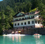
Vacanze al Lago di
Molveno, Dolomiti di Brenta


e-mail
meteo
| |

|
Crossing the Brenta Dolomites, Trentino: from Molveno to Massimeno (Rendena Valley)
Molveno
– Massimeno (Rendena Valley), via the Pedrotti and Dodici Apostoli Refuges
(Ideale path). Itinerary to be undertaken in 2 days.
Start
from the top station of the cable car that goes from Molveno up to the
Altopiano di Pradel tableland (open every day from the last week in May to
the end of September and at weekends from the beginning of May and in the
first three weeks of October (check times and dates by phoning 0461-586981 /
586924).
An alternative access route to the Croz Altissimo Refuge (1,430 m.)
is the Seghe Valley, starting from Molveno near the Via Dolomiti hairpin bend,
on path no. 322 (time from Molveno to the Croz Altissimo Refuge: 1½ hours).
Starting from Pradel, on the other hand, you follow itinerary 340 up to the
Croz Altissimo Refuge which has
the odd exposed stretch but you are protected by a metal barrier (a rope
hand-rail). The route cuts across the western rock face of the Croz Altissimo
peak and offers excellent views over the Sfulmini amphitheatre and over the
peaks that bound the Perse Valley. From the Croz Altissimo Refuge it takes 30
minutes to get to the Selvata Refuge (1,630 metres).
An alternative route to
get from Molveno to this lovely refuge is to take path no. 322, or the Donini
route which begins at the Bar Ciclamino in Pontesel, both of which go via the
Malga Andalo Refuge (1,351 m.). From the Selvata Refuge you carry on along
path no. 319 and after about 50 minutes, having passed two springs, you come
to the former Baita Massodi alpine hut (1,985 m.).
Crossing fields amid
rhododenron and the last mountain pines you come to the Laghet depression;
from here the peaks are so lovely that the view over the Sfulmini, Campanil
Basso and Brenta Alta Group is quite breath-taking. The silence is broken now
and again by the whirring noise of the Pedrotti Refuge cable way which stands
out against the rocks, now close, now far away.
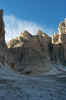
In about 4 – 4½ hours you
come to the Pedrotti Refuge (2,491 m.). From here you take path no. 304 which
goes around the Cima Brenta Bassa peak and in front of the Cima Margherita
and then begins to climb the Tosa hanging glacier with the Pozza Tramontana
hollow lower down on your left. Carry on to the Sella della Tosa saddle
(2,859 m.) and the Bocca della Tosa pass where the Ottone Brentari route with
fixed rope supports begins. At the bottom, on the snowfield, turn sharp right
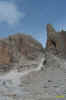
and head for the Ambiez hanging glacier.
Climb up the steep pass (2,871 m.)
and mind the icy stretches. The view to the west encompasses the permanently
snow-capped peaks of the Adamello and Presanella mountains. As you go down
from the Agola hanging glacier, the Ideale path meets path no. 307 which goes
to the Brentei Refuge along the Camosci hanging glacier (Martinazzi path).
Continue straight on and in about 45 minutes you come to the Dodici Apostoli
Refuge (3½ hours from the Pedrotti Refuge, 8 hours from Molveno). From here
take path no. 307 to the Bregn de l’Ors Pass (1,848 m., 1 hour 40 minutes)
and then paths 333 and 354 to the Gotro Pass (10 minutes); finally take path
354 and in less than 2 hours you will come to Massimeno (Rendena Valley).
|
|
| starting
point: |
Molveno- Pradel
( mt 1320) |
| finishing
point: |
Massimeno |
| maximum
height: |
mt 2859 Sella della Tosa |
| difference
in height |
1750 m. |
| time
required |
about 11 hours |
| main
crossing valleys |
Val
dei Massodi, Vedretta della Tosa, vedretta D’Agola, Val di Nardis |
| suggestions
for overnight stays |
rifugio Selvata,
Rifugio Pedrotti (overnight), Rifugio 12 Apostoli, Malga Movlina |
| path
numbers |
nr
340 , 319, 304*, 307, 354 |
| Trentino
bus connections |
Collegamenti
autobus Trentino |
| recommended
period |
june -september |
| difficulty
level |
difficult, only for expert people |

il non sempre
semplice traverso da Bocca Ambiez a base Ferrata Brentari
 |
 |
|
Cartina Malga Movlina Rifugio Pedrotti per gentile concessione Editrice La Giralpina |
Cartina Molveno Rifugio Pedrotti per gentile concessione Editrice La Giralpina |
Table
of times between points and heights:
from Molveno to Massimeno
| area |
path nr. |
height |
time
between areas |
time
from start |
notes,
route variations
|
| Molveno,via
Dolomiti |
319 |
880 |
0 |
0 |
SEE
MAP |
| Baita
Ciclamino, fork Sent.Donini |
319 |
926 |
0,10 |
0,10 |

Rif.Selvata |
| Busa del
Formai, fork 319-322 |
322 |
1300* |
0,50 |
1,00 |
seguendo il
sent. 319 si arriva direttamente al Rif. Selvata |
| Rifugio
Croz.Altissimo, fork 322,340 |
340 |
1430 |
0,30 |
1,30 |
s. 322 per Val
Perse o Passo Clamer |
| Rifugio
Selvata, fork 332 |
319 |
1630 |
0,40 |
2,10 |
per Malga
Andalo |
| fork 319-303 |
319 |
2420 |
2,00 |
4,10 |
s 303 per
Sentiero Orsi |
| Rifugio
Pedrotti |
320 |
2491 |
0,10 |
4,20 |

Sentiero dell'Ideale,n.304 |
| Base sud Cima
Brenta Bassa, b. 320 |
304 |
2470 |
0,10 |
4,30 |
s.320 per R.
Agostini |
| Bocca della
Tosa |
304 |
2845 |
1,20 |
5,50 |
Bocca della Tosa, sud |
| Vedretta d'Ambiez,fork
358 |
304 |
2800* |
0,15 |
6,05 |
s.358 per Rif.
Agostini |
| Bocca d'Ambiez |
304 |
2871 |
0,35 |
6,40 |
Sent. dell'Ideale, 304 |
| Rif.
12 Apostoli |
307 |
2487 |
1,10 |
7,50 |
overnight |
| Vic.ze Passo
Bregn de l'Ors |
354 |
1848 |
1,40 |
9,30 |
Vedretta Prato Fiorito |
| Passo del Gotro |
354 |
1847 |
0,10 |
9,40 |
- |
| Malga
Movlina |
354 |
1781 |
0,10 |
9,50 |

Malga Movlina e Presanella |
| Massimeno |
- |
861 |
2,00 |
11,50 |
- |
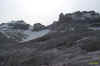
Visualizza Parco Adamello Brenta, Settore Brenta in una mappa di dimensioni maggiori

Panorama verso Rifugio ai 12 Apostoli e Gruppo Presanella Adamello
|


